
Hiking & Running
EXPLORE HIKING IN WEATHERSFIELD
Scenic hiking and running trails every step of the way!
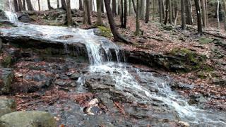
Cascade Falls
Location: 368-2 Weathersfield Trail, Perkinsville, VT 05151
Two waterfalls can be seen from the Weathersfield Trail on Mt. Ascutney, the tallest mountain in southeastern Vermont. Cascade Falls and its sister, Little Cascade Falls, are two highly seasonal waterfalls that are quite attractive when water is actually flowing over them. Due to their high elevation on the slopes of Mt. Ascutney, both waterfalls are often reduced to just a trickle by June or July of every year, except after heavy rains.
Little Cascade Falls is exceptionally seasonal. During a period of drought, there may be such a lack of water that you would be hard-pressed to find any evidence that a waterfall exists here. A visit during a high water period will unveil a pretty horsetail falling approximately 60 feet over several drops.
Cascade Falls, which is often called Crystal Cascade Falls, drains more water off the mountain, and so is a bit less seasonal. The trail to this falls brings you to where the brook drops over a broad ledge. This ledge is 30 feet wide, but the falls is not more than a few feet wide. Better views can be obtained from the side of the cliffs beside the falls, but getting there requires a difficult bushwhack and scramble down a steep slope.
If you are able and willing, keep hiking on the Weathersfield Trail beyond Cascades Falls all the way to the summit of Mt. Ascutney. From Cascade Falls, it is an additional 1.8 miles with 1,400 more feet of elevation gain on moderate terrain to the summit. A fire tower is found on the summit, offering some of Vermont’s premier scenic views. This round trip hike of 5.8 miles is highly recommended for those willing and able to tackle this moderately difficult hike.
Little Ascutney WMA
Location: 549-737 Ascutney Basin Rd, Reading, VT 05062
Check out this 3.5-mile out-and-back trail near Reading, Vermont. Generally considered a moderately challenging route, it takes an average of 2 h 8 min to complete. This trail is great for birding, cross-country skiing, and hiking, and it's unlikely you'll encounter many other people while exploring. The trail is open year-round and is beautiful to visit anytime. Dogs are welcome, but must be on a leash.
Futures Trail
Location: 1826 Back Mountain Rd, Windsor, VT 05089
The Futures Trail was constructed in 1983 by a crew from Vermont Futures -- a program established by the State of Vermont to provide work opportunities to unemployed Vermonters. The trail is located entirely within Ascutney State Park and is 4.1 miles long to its junction with the Windsor Trail and 4.6 miles to the summit of Mt. Ascutney. Blue paint blazes were used to mark the trail. The trail starts by climbing up a steep bank, past an old stone chimney and follows an old logging road along the contour. The logging road ends (0.1mi) and the trail swings right and uphill, climbing the ridge through a series of switchbacks to Bare Rock Vista (1.0 mi, 1,350 ft) offering excellent views to the southwest. The trail then descends the back side of the ridge through a hemlock stand in a series of switchbacks and then resumes climbing (1.1 mi.) through a northern hardwood forest. At 1.5 mi, it crosses a small stream and continues slabbing uphill. It soon crosses another small stream (2.0 mi) and turns sharply uphill through a rocky area. It crosses yet another small stream and then immediately cuts under a power line and climbs to a picnic area parking lot (2.1 mi).
The Mount Ascutney Parkway
The Mount Ascutney Parkway is a 3.7-mile road built by hand and machine by the Civilian Conservation Corps from 1933 to 1937. The CCC established a camp on property acquired for conservation and recreation projects in 1933. During the six year time the camp was active, crews worked on surveying and constructing the parkway, building hiking trails, a campground, a ski jump, picnic sites and forestry projects. Road construction included drilling and blasting much of the route using steam drills, hand tools and some trucks and equipment. The road was paved in the 1960’s concurrent with campground expansion. Today, over 15,000 people enjoy the parkway in the summer months to take in long-range views, hike the summit, camp at the base and participate in foot and bicycle races and auto time trials. Hours and scheduled road closures are posted on the park’s webpage. Mount Ascutney rises 2,500 ft. from the Connecticut River Valley to an elevation of 3,144ft. above sea level, forming a dominating topographical feature visible in both southeastern Vermont and southwestern New Hampshire. Grades average 10% on the parkway with some sections as steep at 19%.
Location:1826 Back Mountain Rd Windsor, VT 05089
Season: May 15 - October 16
Mount Ascutney Windsor Trail
Head out on this 5.3-mile out-and-back trail near Windsor, Vermont. Generally considered a challenging route, it takes an average of 4 h 10 min to complete. This is a popular trail for birding, cross-country skiing, and hiking, but you can still enjoy some solitude during quieter times of day. The trail is open year-round and is beautiful to visit anytime. Dogs are welcome, but must be on a leash.
Location:86 Back Mountain Rd, Windsor, VT 0508906001290
Brownsville Trail
Check out this 6.4-mile out-and-back trail near Windsor, Vermont. Generally considered a challenging route, it takes an average of 4 h 23 min to complete. This is a popular trail for birding, hiking, and snowshoeing, but you can still enjoy some solitude during quieter times of day. The trail is open year-round and is beautiful to visit anytime. Dogs are welcome, but must be on a leash.
Location: 3215 Route 44, Windsor, VT 05089